Below you will find the list of references that are used in this fact sheet; all sources can be consulted or retrieved. Via Publications you can find more literature on the subject of road safety.
[1]. CROW (2021). Afwegingskader 30 km/h. Kennisplatform CROW, Ede.
[2]. CROW (1997). Handboek categorisering wegen op duurzaam veilige basis. Deel 1: (voorlopige) functionele en operationele eisen. Publicatie 116. Kennisplatform CROW, Ede.
[3]. Dijkstra, A. (2011). En route to safer roads: How road structure and road classification can affect road safety. PhD dissertation University Twente, SWOV Dissertatiereeks. SWOV, Leidschendam.
[4]. Dijkstra, A. (2003). Infrastructurele verkeersvoorzieningen en hun veiligheidsaspecten; De betekenis van de verschillende soorten verkeersvoorzieningen voor een duurzaam-veilig verkeers- en vervoerssysteem [Infrastructural traffic provisions and their safety aspects. The meaning of the various types of traffic provisions for a sustainably-safe traffic and transport system]. D-2003-5 [Summary in English]. SWOV, Leidschendam.
[5]. CROW (2013). Handboek wegontwerp 2013; Regionale stroomwegen. Kennisplatform CROW, Ede.
[6]. RWS (2015). Richtlijn Ontwerp Autosnelwegen ROA 2014. Ministerie van Infrastructuur en Milieu, Rijkswaterstaat, Grote Projecten en Onderhoud GPO, Rijswijk.
[7]. Vos, J. (2017). Richtlijn Ontwerp Autosnelwegen 2017. Rijkswaterstaat.
[8]. Fortuijn, L.G.H., Carton, P.J. & Fedds, B.J. (2005). Veiligheidseffect van kruispuntplateaus in gebiedsontsluitingswegen. Proceedings of the Verkeerskundige Werkdagen 2005. CROW, Ede.
[9]. CROW (2021). ASVV 2021. Artikelnummer 740. Kennisplatform CROW, Ede.
[10]. CROW (2016). Ontwerpwijzer fietsverkeer. Publicatie 351. CROW Kenniscentrum voor verkeer, vervoer en infrastructuur, Ede.
[11]. Veroude, B., Gurp, M. van & Boggelen, O. van (2022). Geactualiseerde aanbevelingen voor de breedte van fietspaden 2022. CROW-Fietsberaad.
[12]. Wolters, S. & Gurp, M. van (2022). Geactualiseerde aanbevelingen voor markering op fietspaden 2022. CROW-Fietsberaad.
[13]. Uijtdewilligen, T., Gebhard, S.E., Weijermars, W.A.M., Nabavi Niaki, M. & Dijkstra, A. (2022). Safe cycling routes; Road safety indicators for cycling routes. R-2022-6A. SWOV, Den Haag.
[14]. SWOV & CROW (2020). Wanneer zijn wegen en fietspaden 'voldoende veilig'? Factsheet KN SPV 2020-8. Kennisnetwerk SPV, Utrecht
[15]. Schepers, J.P., Kroeze, P.A., Sweers, W. & Wüst, J.C. (2011). Road factors and bicycle–motor vehicle crashes at unsignalized priority intersections. In: Accident Analysis & Prevention, vol. 43, nr. 3, p. 853-861.
[16]. Nabavi Niaki, M., Wijlhuizen, G.J. & Dijkstra, A. (2021). Safety enhancing features of cycling infrastructure: Review of evidence from Dutch and international literature. R-2021-20. SWOV, The Hague.
[17]. Nabavi Niaki, M., Dijkstra, A. & Wijlhuizen, G.J. (2021). Bicycle safety before and after the redesign of intersections in The Hague; Assessment using automated traffic analysis software. R-2021-4A. SWOV, Den Haag.
[18]. Cantisani, G., Moretti, L. & De Andrade Barbosa, Y. (2019). Risk analysis and safer layout design: solutions for bicycles in four-leg urban intersections. In: Safety, vol. 5, nr. 24.
[19]. Schepers, P. (2013). A safer road environment for cyclists. PhD Thesis Technical University Delft, SWOV-Dissertatiereeks. SWOV, Leidschendam.
[20]. SWOV & CROW (2019). Verkeersveiligheid bij kruispunten met verkeerslichten. Factsheet SPV-D5. Kennisnetwerk SPV, Utrecht.
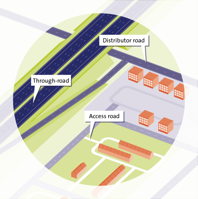
[21]. CROW (2012). Basiskenmerken wegontwerp: categorisering en inrichting van wegen. Publicatie 315. Kennisplatform CROW, Ede.
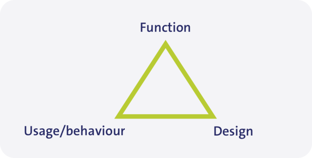
[22]. Theeuwes, J. & Diks, G. (1995). Categorisering van omgevingen: een overzicht van de literatuur. TM 1995 B-2. TNO Technische Menskunde, Soesterberg.
[23]. Aarts, L.T., Davidse, R.J. & Christoph, M. (2007). Herkenbaar wegontwerp en rijgedrag. Een rijsimulatorstudie naar herkenbaarheid van gebiedsontsluitingswegen buiten de bebouwde kom [Recognizable road design and driving behaviour. A driving simulator study of the recognizability of rural distributor roads]. R-2006-17 [Summary in English]. SWOV, Leidschendam.
[24]. Stelling-Konczak, A., Aarts, L., Duivenvoorden, K. & Goldenbeld, C. (2011). Supporting drivers in forming correct expectations about transitions between rural road categories. In: Accident Analysis & Prevention, vol. 43, nr. 1, p. 101-111.
[25]. Kint, S.T. van der, Schermers, G., Gebhard, S.E. & Hermens, F. (2022). Veilige Snelheden, Geloofwaardige Snelheidslimieten (VSGS). Hoe valide is de GS-bepaling met de VSGS-methode? [Safe Speeds, Credible Speed Limits: How valid is the credible speed limit methodology?] R-2022-5 [Summary in English]. SWOV, Den Haag.
[26]. CROW (2011). Seniorenproof wegontwerp. Kennisplatform CROW, Ede.
[27]. Veiligverkeer (2023). Blijf veilig mobiel. Accessed on 02-03-2023 at vvn.nl/blijf-veilig-mobiel.
[28]. Zwijnenberg , H. (2018). Infrastructuur gereedmaken voor automatisch rijden: Technische analyse van voorzieningen in digitale en fysieke infrastructuur. Goudappel, in opdracht van het ministerie van Infrastructuur en Waterstaat.
[29]. CBS (2023). Leeftijdsverdeling. Accessed on 02-03-2023 at www.cbs.nl/nl-nl/visualisaties/dashboard-bevolking/leeftijd/bevolking.
[30]. CBS (2020). Prognose bevolking; geslacht, leeftijd, achtergrond en generatie, 2021-2070. CBS. Accessed on 6 april 2022 at opendata.cbs.nl/#/CBS/nl/dataset/84872NED/table?dl=6EBB9.
[31]. CROW (2021). Toepassen STOMP: Voor duurzame gebiedsontwikkeling. Kennisplatform CROW, Ede.
[32]. KiM (2021). Mobiliteitsbeeld 2021. Kennisinstituut voor Mobiliteitsbeleid | KiM, Den Haag.
[33]. Knaap, P. van der (2021). Veilig innoveren: toelating van LEV’s en de toekomst van fietspaden; Een perspectief. R-2021-11. SWOV, Den Haag.
[34]. Gemeente Amsterdam (2022). Volg het beleid: Verkeersveiligheid. Acceessed on 02-03-2023 at www.amsterdam.nl/bestuur-organisatie/volg-beleid/verkeer-vervoer/verkeersveiligheid/.
[35]. Snoeren, P.W.M. (2008). Een bon voor de wegbeheerder? Vrijheid in vormgeving en inrichting van wegen aan banden. Afstudeerscriptie Nederlands Recht, Universiteit van Utrecht.
[36]. Nieuws Fietsberaad (2021). Meeste fietsstroken zijn te smal. CROW. Accessed on 02-03-2023 at www.fietsberaad.nl/Kennisbank/Meeste-fietsstroken-zijn-te-smal?URLReferrer=searchtext%3dtoepassing%2brichtlijnen%26sort%3d0%26aliaspath%3d%252fKennisbank.
[37]. Bax, C., Petegem, J.H. van & Giesen, M. (2014). Passen gemeenten de Ontwerpwijzer Fietsverkeer toe? Gebruik van de richtlijnen voor fietsinfrastructuur en factoren die dit beïnvloeden. R-2014-23. SWOV, Den Haag.
[38]. Bax, C., Petegem, J.H. van, Vissers, L., Davidse, R.J., et al. (2017). Benutting van de CROW-publicatie Seniorenproof wegontwerp. Kenmerken fietsinfrastructuur in 21 gemeenten [The extent to which the CROW publication ‘Road design suitable for seniors’ is followed. Features of the cycling infrastructure in 21 municipalities in the Netherlands]. R-2017-9 [Summary in English]. SWOV, Den Haag.