Principles for a safe road network

Updated

The construction of the road network and road design greatly affect road safety: firstly, because they make certain conflicts impossible or unlikely (e.g., by physical separation of driving directions, separate bicycle tracks, clear roadsides); secondly, because they direct the desired traffic behaviour (recognisability, predictability).

The Netherlands uses three road categories: access roads, distributor roads and through-roads. Each road type has its own design principles, for both road sections and intersections. The guidelines for optimal road design (balancing accessibility, safety and the environment) are published by CROW, the technology platform for transport, infrastructure and public space in the Netherlands. The guidelines are not binding; ultimately it is the road authority that decides on the road design

How is the road network in the Netherlands structured?

The Dutch road network is structured according to the principle of functional network construction. This implies that, first of all, a network distinguishes between a residential function (intended for residence without travelling purposes), and a traffic function (intended for traffic flow). A further distinction is made between the traffic functions of flow and exchange. In the case of flowing traffic, traffic does not interact with the environment; conversely, in the case of exchange there is interaction with the environment and abrupt manoeuvres are possible. Flowing and exchanging do not go together safely. The Sustainable Safety principles require the two functions to be kept strictly separate (mono-functionality of a road). On roads in a residential area, there are only exchanges; on roads with a traffic function, traffic flows on the road sections, and there is exchange at intersections

Which road categories are distinguished in the Netherlands?

Based on the functional network structure and the Sustainable Safety vision (see SWOV fact sheet Sustainably safe road traffic), the Netherlands has three main road categories (see the question How is the road network in the Netherlands structured?). Each road category has its own design principles and features:

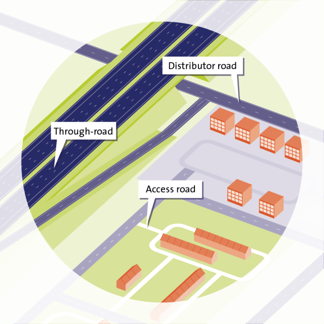
Through-roads allow traffic to travel from origin to destination as quickly and safely as possible (“flow”). Car traffic has the highest priority. Through-roads may only be situated outside urban areas. These are either trunk roads or motorways.

Distributor roads connect through-roads with access roads. Traffic flows at road sections and exchange occurs at intersections. Distributor roads are found in both urban and rural areas. They are mainly 50-and 70 km/h roads in urban areas and 80 km/h roads in rural areas. Recently, a new type of distributor road has been proposed: a distributor road with a 30km/h limit. It concerns distributor roads that cannot be safely designed as 50km/h roads and/or have both a traffic function and residential function [1].

Access roads (ETW) offer direct access to residential areas at the locations of origin and destination. The residential function is most important and car traffic needs to adapt (in particular by travelling at low speeds). Access roads can be found in urban areas and in rural areas. It concerns 30 km/h roads and home zones (15 km/h) in urban areas and 60 km/h roads in rural areas.

fs_roaddesign_fig1.png

Figure 1. Road categories.

Why are roads categorized?

The categorisation of roads is helpful to road authorities as well as to road users.

Road authorities

Categorisation of roads allows road authorities to ensure efficient traffic flow in their management areas: through-traffic between two residential areas, for example, needs to be directed to a through-road as quickly as possible. Furthermore, the categorisation of roads provides handles for the design (features and layout) of the roads.

Road users

In principle, categorisation of roads is also helpful to road users. It is essential that roads with different functions have a consistent layout (recognisability). This way, road users will know how they are expected to behave, which other road users they can encounter and how these are likely to behave (predictability).

What is the road design based on?

The road design is in fact based on the triangle Function – Design – Usage/behaviour which is also used by designers outside the 'traffic' work field.

Figure


This triangle indicates that the function or purpose of the road should be reflected by the design (features and layout) and that the road design should evoke the intended and desired behaviour and road usage. When applied to traffic, this means that each of the three road types (through-roads, distributor roads, and access roads) requires a road design that results in the intended and desired use by road users. From the perspective of the road user, the design must make clear what the intended function/road category is and (thus) what the desired use and behaviour should be. We denote this with 'recognisability' and 'predictability'.

The concrete elaboration of design features is based on the Sustainable Safety concept and the Sustainable Safety principles of Functionality, (Bio)mechanics, and Psychologics (see SWOV fact sheet Sustainably safe road traffic).

What are the general requirements for a safe road network and road design and why are they important?

The Sustainable Safety vision has led to twelve general functional requirements for a safe road network, safe routes and a safe road design [2].

At the road network level, the requirements are:

1.    Make residential areas as large as possible and contiguous.
2.    Make sure that the amount of travel on relatively unsafe roads is as small as possible.
3.    Make journeys as short as possible.
4.    Make sure that the concepts 'shortest path' and 'safest path' coincide.

Network-level requirements ensure that residential areas are almost exclusively used by traffic that has its destination or origin there. Pedestrians and cyclists in residential areas therefore encounter less motorised traffic; this increases safety [3]. Exposure to hazards and to traffic in general diminishes when requirements 2, 3 and 4 are complied with.

At route level:

5.    Prevent search behaviour.
6.   Make road categories as predictable as possible.
7.    Limit the number of safety solutions and make them more uniform.

These route-level requirements allow traffic to use the roads as much as possible in a way for which they were designed. Road design is tailored to the intended use; it increases safety especially if actual use does not deviate too much from intended use.

At the level of road design:

8.    Prevent conflicts with oncoming traffic.
9.    Prevent conflicts with crossing and traversing traffic.
10.   Separate traffic types.
11.    Reduce the speed at potential conflict points.
12.    Prevent obstacles along the carriageway.

The requirements of the road design are intended to prevent crashes and to reduce the severity of the consequences of unavoidable crashes. By means of these requirements, possible conflicts between vehicles are prevented to a maximum extent, for example by separating driving directions [4].

What are important safety principles for the design of through-roads?

Through-roads, i.e., trunk roads and motorways, are exclusively intended for high-speed travel from A to B (flow function) and are only accessible for fast traffic.

Motorways consist of at least 2x2 lanes and the driving directions are always physically separated, generally by a median strip and/or guardrail. On the right side, motorways usually have a wide emergency lane and a wide clear zone. The standard speed limit on motorways is 100 km/h during the day (6 - 19h) and 130 km/h in the evening and at night (19 - 6h). Deviations from this standard speed limit are made at a number of locations, for example for reasons of road safety or the environment. At those locations a speed limit of 80, 100 (also at night) or 120 km/h at night applies. The local speed limit may also depend on, for example, whether or not the rush-hour lane is open. In specific circumstances such as traffic jams, road works or bad weather, the speed limit may be temporarily reduced and the adjusted limit displayed on the matrix signs above the road. Trunk roads consist of at least 2x1 lane and usually have a speed limit of 100km/h.

Trunk roads are generally less safely designed than motorways and have, for example, narrower lanes and less wide clear zones. From a Sustainable Safety perspective, physical separation of driving directions is desirable on trunk roads because head-on crashes at driving speeds higher than 70km/h often have a fatal outcome. In practice, however, there are also trunk roads without physical separation of driving directions, but with a double continuous line with a green space between the lines.

Intersections with and between motorways are always grade separated. In principle, intersections between trunk roads should also be grade separated, but in practice this is not (yet) always the case. Intersections between trunk roads and distributor roads are also preferably grade separated, or else signalised.

For more information on the design of through-roads, see the relevant design guidelines [5] [6] [7].

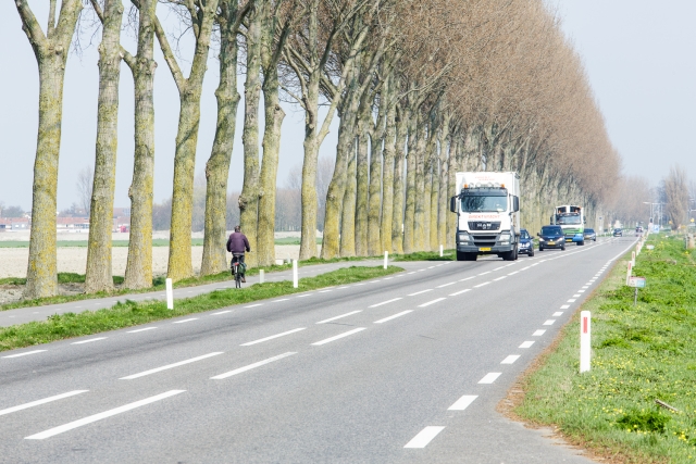
Figure 2. Examples of through-roads. Left: a motorway (Photo: Paul Voorham) and right: a trunk road (Photo: www.dirkdebaan.nl).

What are important safety principles for the design of distributor roads?

Distributor roads connect access roads with through-roads. A distributor road facilitates both flow (on the road sections) and exchange of traffic (at the intersections) [5]. The driving speeds of motorised traffic are therefore higher than on access roads and, from a road safety perspective, cyclists need their own separate facilities (see SWOV fact sheet Infrastructure for pedestrians and cyclists). Exchange takes place at the intersections. This is where motorised traffic and cyclists and pedestrians meet and where the speed of motorised traffic must be lower than on the road sections. This can be done, for example, by means of a roundabout, raised intersection or speed bumps.

Mainly for capacity reasons, two road types are distinguished within the distributor road category [5]:

  • road type I: dual carriageway, cross section with 2x2 lanes;
  • road type II: single carriageway, cross section with 1x2 lanes.

Urban areas

Urban distributor roads usually have a 50 km/h speed limit, sometimes a 70 km/h limit. There are often separate facilities for cyclists and light moped riders. Preferably this is a physically separated bicycle track. Less safe, but also often applied, is a bicycle lane, separated from the lanes for motorised traffic by a (dis)continuous line. On road sections with a 50 km/h speed limit, moped riders generally use the carriageway, and on road sections with a 70km/h limit they use the bicycle/moped track.

Recently, a new type of distributor road has been proposed with a speed limit of 30km/h (see the question (zie de vraag Which road categories are distinguished in the Netherlands?). It is advisable to lower the speed limit to 30km/h for distributor roads where a separate bicycle track cannot be realised. In 2023, CROW intends to present recommendations for the design of 30km/h distributor roads.

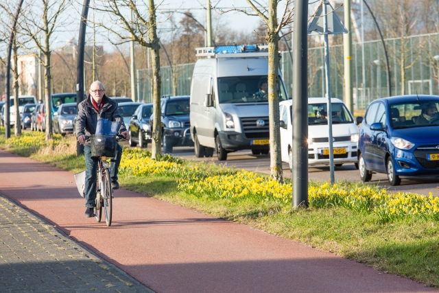
Figure 3. Urban distributor road (Photo: Paul Voorham).

Rural areas

Distributor roads outside urban areas generally have an 80 km/h speed limit. On the road sections, the bicycle facilities are always physically separated. Mopeds must use the bicycle/moped track here. Because of the great speed differences, agricultural traffic should, in principle, not use the lanes of a distributor road, nor should it use the bicycle/moped track due to the large mass differences. However, this can often not be realised for lack of parallel roads or realistic alternative routes. Preferably, the driving directions are physically separated. In practice, however, many distributor roads outside urban areas have no physical driving direction separation, but a double centre line marking (preferably continuous, minimum variant guidelines) or even a single centre line marking (not in accordance with guidelines).

Figure 4. Rural distributor road, without physical separation of driving directions, with double centre lines (Photo: Paul Voorham).

Intersections

  • In principle, intersections between two distributor roads are not grade separated and are preferably regulated by means of a roundabout (see SWOV fact sheet Roundabouts and other intersections). In some cases, for example when traffic volumes are high, a roundabout is not possible due to traffic flow concerns. Then traffic signals are necessary. Sometimes intersections are raised just in front of the signalised intersection to reduce speeds at the intersection to about 50 km/h [8].
  • At intersections between a distributor road and an access road, the traffic on the distributor road has priority.
  • An intersection between a distributor road and a through-road is in principle grade separated. It is important that the entry ramp to a motorway is clearly distinguishable from the exit, in order to prevent unintentional wrong-way driving (see also SWOV fact sheet Wrong-way driving). Sometimes an at-grade intersection is applied, usually controlled by traffic lights.

For more information about the design of distributor roads, see CROW publications [5] [9].

What are important safety principles for the design of access roads?

Access roads are located in residential areas and provide access to homes, businesses, schools, shops, etc. This means that the residential function is more important than the traffic function and that all types of traffic mix: pedestrians, cyclists, cars, and trucks. Because of the great difference in mass between the road users and the fact that pedestrians and cyclists are largely unprotected, motorised traffic should drive at low speeds.

Figure 5. Urban access road (Photo: Paul Voorham).

Urban areas

Access roads in urban areas have a 30 km/h speed limit. Supporting this limit usually requires physical speed inhibitors. For more information, see SWOV fact sheet 30 km/h zones. In addition to 30km/h access roads there are home zones. Home zones have a 15 km/h speed limit and pedestrians can use the entire width of the street for walking and playing. Home zones can not only be found in residential areas, but also in shopping areas and in the vicinity of train stations.

Rural areas

The speed limit on rural access roads is 60 km/h. From a Sustainable Safety perspective, 40km/h would be preferable, but in determining the requirements for the various road categories, 60km/h was chosen. This is a compromise between requirements for traffic flow on the one hand and requirements for safety on the other hand. In special situations, for example when the access road is a parallel road with only destination traffic, at an important (bicycle) crossing or on access roads in quiet areas, a speed limit of 30 km/h may be set [5].

Generally, physical speed inhibitors on access roads are only used at intersections (raised intersections). Road sections are often fitted with edge strips (a discontinuous line at some distance from the roadsides, sometimes asphalted in red), whereby a driving strip for motor vehicles is created in the middle of the carriageway. This leads to a visual narrowing of the road which results in lower speeds. In case of sufficient width, the edge strips on either side of the driving strip can be used by cyclists. For more information, see the archived SWOV fact sheet Edge strips on rural access roads.

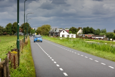
Figure 6. Rural access road (Photo: Paul Voorham).

Intersections

  • Intersections between access roads are at grade and without any designated priorities (priority for traffic from the right).
  • Intersections between an access road and a distributor road are also at grade. Traffic on the distributor road has priority. The connection from the access road preferably has a so-called exit structure, but traffic signs (RVV signs B1 to B7) are also possible.

Figure 7. Access road ending in an exit construction (Photo: Paul Voorham).

More information on the design of access roads can be found in the CROW publications on this topic [5] [9].

What are important safety principles for cycling infrastructure?

Cyclists may use solitary bicycle/moped tracks, access roads and distributor roads, and intersections between these road types. Safety principles for bicycle tracks, road sections and intersections are presented below. For more information on the design of bicycle facilities, see the Ontwerpwijzer Fietsverkeer (Design Guide for Bicycle Traffic) [10] and the updated recommendations for bicycle track widths and guidelines for markings on bicycle tracks [11] [12]. For more information on facilities for cyclists, see also SWOV fact sheet Infrastructure for pedestrians and cyclists.

Safety principles have also been defined at the route level. In 2022, SWOV proposed seven features for bicycle route safety [13]. These features are aimed at minimising exposure to road unsafety and avoiding conflicts with motorised traffic.

Bicycle tracks

Kennisnetwerk SPV (Knowledge network SPV) has drawn up risk indicators for safe bicycle tracks. These include the following design principles [14]:

  1. no obstacles;
  2. good visual guidance, for example by means of edge markings;
  3. sufficient width;
  4. pavement is flat, skid-resistant, whole and clean;
  5. forgiving edge;
  6. forgiving roadside.

Road sections

On the road sections of distributor roads, motorised traffic travels at high speeds and should be able to flow. Road safety requires physical separation between motorised traffic and cyclists by means of separate bicycle tracks. In the construction of bicycle facilities along road sections, it is important to ensure that no conflicts may arise between parking vehicles (manoeuvres, car doors being opened and disembarking passengers) and passing cyclists.

Intersections

At intersections, cyclists mix with car traffic, and travel speeds of motorised traffic should therefore be lower than on the connecting road sections. When roundabouts have been applied, the speeds driven are automatically quite low (see SWOV fact sheet Roundabouts and other intersections). At other types of intersections, a lower speed may be enforced by speed-reducing measures such as speed humps just before the intersection or a raised intersection (plateau). In addition, it is safer if the bicycle crossing at the intersection is deflected 2 to 5 meters from the carriageway, which is also referred to as "deflecting" the bicycle track [15] [16] [17] [18]. On busy roads, a median allows cyclists to cross the road more safely. At intersections, relatively more crashes occur on two-way bicycle tracks than on one-way bicycle tracks [19].

At intersections where large groups of cyclists want to turn left, cyclists often have to wait twice, which encourages red light negation. To reduce this, measures such as push buttons with a waiting signal, waiting time predictors (if properly applied) and four-way green can be applied [20].

What are important safety principles for tunnels?

Important road safety principles for tunnels include careful design of the tunnel entrance and exit, proper lighting, limiting ramps and tight turns, and proper drainage. Emergency lanes increase the space to the tunnel walls, and allow vehicles with breakdowns to stop safely. However, emergency lanes are generally not used in tunnels for cost-effectiveness reasons. Finally, discontinuities (merge and exit lanes, splits, weaves, lane terminations and additional lanes) should be avoided both near tunnels and in tunnels themselves, especially where emergency lanes are not provided.

For more information on tunnel safety, see the archived SWOV fact sheet The road safety of motorway tunnels and information on Rijkswaterstaat’s Steunpunt Tunnelveiligheid (Tunnel Safety Support Center). The Richtlijn Ontwerp Autosnelwegen (Design Standards for Motorways) (ROA, 2019) contains design guidelines for tunnels.

Which design elements increase the predictability of a road?

In the Netherlands, the predictability of roads is mainly executed by using markings that differ per road category. CROW has prepared guidelines on the essential features for recognisability of road infrastructure and these have now been included in the Manual for Road Design [21]. Table 1 shows the markings to be used. They have been implemented on most roads.

Making roads predictable ensures that road users always know what kind of road they are driving on, who they may encounter there (predictability) and how to behave. For the predictability of roads, it is important not only to distinguish between road categories, but also to have uniformity within road categories [22].

Public communication can improve the knowledge about the meaning of road markings, but in practice it appears that driving behaviour is mainly intuitively evoked by the design of the road [23] [24]. For more information, see the archived SWOV fact sheet Recognisable road design.

Recognisable road design ensures that road users know how to behave, but this does not imply that they actually do. To achieve this, it is important that correct behaviour is also provoked or enforced, for example by a credible speed limit, speed reducing measures or by making overtaking physically impossible. For more information on a credible speed limit, see for example [25] and SWOV fact sheet Speed and speed management.

Table

Table 1. Elaboration of essential predictability features [21]. Each road type has its own zone indication; the marking is elaborated per road type and can be applied in both urban and rural areas. The elaboration of physical driving direction separation for through-roads applies to both regional (SW100) and national through-roads (SW130). In accordance with the guidelines, a green centre marking can also be chosenn.

What is seniorproof road design?

Seniorproof road design means that the infrastructure is tailored to older road users. Seniors may have functional limitations compared to younger road users, which means they need more time to see things properly, decide and then act. It is important to take this into account in the design of a road. It is also important to design traffic situations in such a way that they match the experience-based expectations of older road users. These conditions broadly correspond to the Sustainable Safety principles for safe road design. However, certain types of design sometimes require better adaptation to older road users. This includes, for example, that:

  • new designs are consistent with existing principles so that older road users can make use of their experience and existing automatisms;
  • complex tasks can be performed in steps (e.g., crossing in stages), each time allowing the older road users to review the situation at a safe spot and determine their own time constraints;
  • important features of the infrastructure are prominent, for example by proper lighting and high-contrast markings.

For more information on seniorproof road design, see CROW's design guidelines [26] a brochure issued by partnership Blijf Veilg Mobiel (Stay Safely Mobile) [27] and SWOV fact sheet Older road users.

What developments should be considered in designing roads?

Developments to consider in designing roads are developments in vehicle automation, the ageing population and increased use of (new forms of) active modes of transport.

More partially self-driving cars

More and more (new) vehicles are equipped with smart 'advanced driver assistance' systems (ADAS) such as lane keeping assistance, adaptive cruise control and blind spot detectors. In addition, there are now vehicles on the market in which part of the driving task is automated and which, for example, brake, accelerate and steer independently (see also SWOV fact sheet Self-driving vehicles). Since the lifespan of road infrastructure is about 30 years, these developments must be taken into account when building and redesigning roads. At the request of the Ministry of Infrastructure and Water Management, identification took place of the minimum facilities required to ensure road safety for all road users when automated vehicles are used in traffic [28]. Requirements for both the physical and the digital infrastructure were considered. With regard to the physical infrastructure, this involves requirements for road design, quality of the road surface, marking, signs and signage, and the subsequent compliance with these requirements. Some of these requirements can also be found in a more recent article in NM magazine, which discusses what measures road authorities can take to increase the effect of ADAS:

  • Reduce the chances of lane boundaries not being detected by increasing the contrast value of  markings until a highly accurate GPS system is available.
  • Ensure the legibility of speed signs and regulations on (inadvertent) visibility of speed signs to road users for whom the sign is not intended.
  • Develop an accurate and up-to-date digital map.
  • Make traffic light control suitable for communication with vehicles.

Ageing

In recent decades, the proportion of the over-65s in the Dutch population has gradually increased. In 1980, 11% of the population was older than 65, in 2020 it was 20% [29]. According to a forecast by Statistics Netherlands, the share of the over-65s in the Dutch population will continue to rise to 26% around 2040 [30]. It will therefore become even more important to consider older road users when designing roads: see the question What is seniorproof road design?.

Increased use of (new forms of) active modes of transport

More and more people are cycling in the Netherlands. Mobility policy aims to promote cycling and walking because these modes of transport are healthy, environment-friendly and take up less space than motorised vehicles. This also affects the process of road design: CROW has published the STOMP[i] design principle [31], which prioritises sustainable forms of mobility in the design process.

Besides the use of active modes of transport, the variety of available (more or less) active modes of transport is also increasing. An increasing share of bicycle distance is travelled on pedelecs: KiM expects the share of pedelecs in total bicycle use to increase from 24% in 2019 to 46% in 2026 [32]. The popularity of speed pedelecs is also growing steadily (see SWOV fact sheet Pedelecs and speed pedelecs). In addition, a variety of new LEVs (Light Electric Vehicles) are under development (see SWOV fact sheet Light Electric Vehicles (LEVs)). These new modes of transport are not always easy to fit into the current traffic system. To ensure the safety of cyclists, only vehicles that are similar to regular bicycles in size, weight, speed and function can safely travel on bicycle tracks [33]. This means that vehicles that do not meet these requirements would have to be directed to the carriageway, which is used by vehicles faster and heavier than regular bicycles. There, however, other forms of incompatibility arise. For example, speed pedelecs are not easily compatible in terms of travel speed: they travel faster than cyclists on bicycle tracks, but slower than cars on the carriageway.


[i] In Dutch: Stappen, Trappen, OV, MaaS, Prive-auto. Best translated as: Walking, Pedalling, Public Transport, MaaS, Private Car

What tools are available to test the safety of road infrastructure?

There are several instruments that road authorities can (commission to) use to test the safety of their road network and their roads. These provide an overview of possible safety bottlenecks and (consequently) of the targets for action.

Planning and designing tests

The safety of a new road or a far-reaching redesign of a road can be tested in advance by carrying out a road safety audit in various phases of the planning and of the design (see archived SWOV fact sheet The Road Safety Audit and Road Safety Inspection). Under European regulations, it is mandatory to conduct road safety audits when building or reconstructing national and provincial trunk roads.

Testing existing roads and cycling infrastructure

Various tests can be used to test the safety of existing road infrastructure. The SPV Knowledge Network provides an overview of measurement tools for the safe roads risk indicator.

When is a location a “black spot”?

A black spot (or hot spot) is a location where many road crashes occur. This may refer to the absolute number of crashes or the number of crashes related to road length or traffic volume. The Working group Black spots Amsterdam (WBA), for example, defines black spots as locations where at least three (injury) crashes have occurred in the past three years [34].

The purpose of identifying black spots is to select high-priority locations to spend safety budgets effectively. Fortunately, there are fewer and fewer black spots in the Netherlands. The black spot approach is therefore increasingly being replaced by a risk-based approach, where locations are prioritised based on their risk indicator score. The advantage of the risk-based approach is that measures can be taken before unsafe situations have resulted in crashes. For more information on the risk-based approach, see the Knowledge network SPV website.

How are the guidelines for road design developed?

Guidelines for road design and road layout are published by CROW, the knowledge platform for infrastructure, traffic, transport and public space in the Netherlands. These guidelines are made in so-called CROW working groups which are formed by traffic and road safety experts from various local authorities, consultancy firms and knowledge institutes. The guidelines are often a compromise between accessibility, environment and safety. Where possible, guidelines are substantiated by scientific knowledge, but as yet not sufficient scientific knowledge is available for all aspects.

Is complying with the guidelines mandatory?

In the Netherlands the guidelines for road design are not legally binding. A road authority should, however, have good reasons to deviate from the guidelines as it is responsible for the quality of its roads [35]. In the event of a crash on a road where the guidelines have not been properly applied, the road authority may be held liable. In a possible lawsuit, the road authority must be able to motivate why the guidelines were not complied with. It must also prove that the chosen alternative is at least equally safe.

To what extent are guidelines put into practice?

According to several studies, guidelines are not always applied in practice. For example, a study of the widths of bicycle tracks/lanes found that 60% of bicycle lanes along 50km/h roads were narrower than recommended in the guidelines [36]. Research conducted in 2014 [37] found that nearly half of the seventy municipalities surveyed could not indicate whether their bicycle infrastructure generally complied with the “Ontwerpwijzer Fietsverkeer” (Design Guide for Bicycle Traffic). Observations in two municipalities show that especially the guidelines for the widths of bicycle tracks/lanes, profiled marking before bicycle bollards, and clear zones are often not applied [37]. Research on application of the design suggestion "Seniorproof road design" in 2017 [38] showed that both self-reported and measured use of the design suggestions is lower than that of the Bicycle Traffic Design Guide.

There are several reasons why guidelines are not implemented. For example, there may not be enough space, the costs may be too high or there may be a lack of priority. Sometimes there are also substantive reasons to deviate from the guidelines: in such cases, different road safety interests conflict.

Publications and sources

Below you will find the list of references that are used in this fact sheet; all sources can be consulted or retrieved. Via Publications you can find more literature on the subject of road safety.

[1]. CROW (2021). Afwegingskader 30 km/h. Kennisplatform CROW, Ede.

[2]. CROW (1997). Handboek categorisering wegen op duurzaam veilige basis. Deel 1: (voorlopige) functionele en operationele eisen. Publicatie 116. Kennisplatform CROW, Ede.

[3]. Dijkstra, A. (2011). En route to safer roads: How road structure and road classification can affect road safety. PhD dissertation University Twente, SWOV Dissertatiereeks. SWOV, Leidschendam.

[4]. Dijkstra, A. (2003). Infrastructurele verkeersvoorzieningen en hun veiligheidsaspecten; De betekenis van de verschillende soorten verkeersvoorzieningen voor een duurzaam-veilig verkeers- en vervoerssysteem [Infrastructural traffic provisions and their safety aspects. The meaning of the various types of traffic provisions for a sustainably-safe traffic and transport system]. D-2003-5 [Summary in English]. SWOV, Leidschendam.

[5]. CROW (2013). Handboek wegontwerp 2013; Regionale stroomwegen. Kennisplatform CROW, Ede.

[6]. RWS (2015). Richtlijn Ontwerp Autosnelwegen ROA 2014. Ministerie van Infrastructuur en Milieu, Rijkswaterstaat, Grote Projecten en Onderhoud GPO, Rijswijk.

[7]. Vos, J. (2017). Richtlijn Ontwerp Autosnelwegen 2017. Rijkswaterstaat.

[8]. Fortuijn, L.G.H., Carton, P.J. & Fedds, B.J. (2005). Veiligheidseffect van kruispuntplateaus in gebiedsontsluitingswegen. Proceedings of the Verkeerskundige Werkdagen 2005. CROW, Ede.

[9]. CROW (2021). ASVV 2021. Artikelnummer 740. Kennisplatform CROW, Ede.

[10]. CROW (2016). Ontwerpwijzer fietsverkeer. Publicatie 351. CROW Kenniscentrum voor verkeer, vervoer en infrastructuur, Ede.

[11]. Veroude, B., Gurp, M. van & Boggelen, O. van (2022). Geactualiseerde aanbevelingen voor de breedte van fietspaden 2022. CROW-Fietsberaad.

[12]. Wolters, S. & Gurp, M. van (2022). Geactualiseerde aanbevelingen voor markering op fietspaden 2022. CROW-Fietsberaad.

[13]. Uijtdewilligen, T., Gebhard, S.E., Weijermars, W.A.M., Nabavi Niaki, M. & Dijkstra, A. (2022). Safe cycling routes; Road safety indicators for cycling routes. R-2022-6A. SWOV, Den Haag.

[14]. SWOV & CROW (2020). Wanneer zijn wegen en fietspaden 'voldoende veilig'? Factsheet KN SPV 2020-8. Kennisnetwerk SPV, Utrecht

[15]. Schepers, J.P., Kroeze, P.A., Sweers, W. & Wüst, J.C. (2011). Road factors and bicycle–motor vehicle crashes at unsignalized priority intersections. In: Accident Analysis & Prevention, vol. 43, nr. 3, p. 853-861.

[16]. Nabavi Niaki, M., Wijlhuizen, G.J. & Dijkstra, A. (2021). Safety enhancing features of cycling infrastructure: Review of evidence from Dutch and international literature. R-2021-20. SWOV, The Hague.

[17]. Nabavi Niaki, M., Dijkstra, A. & Wijlhuizen, G.J. (2021). Bicycle safety before and after the redesign of intersections in The Hague; Assessment using automated traffic analysis software. R-2021-4A. SWOV, Den Haag.

[18]. Cantisani, G., Moretti, L. & De Andrade Barbosa, Y. (2019). Risk analysis and safer layout design: solutions for bicycles in four-leg urban intersections. In: Safety, vol. 5, nr. 24.

[19]. Schepers, P. (2013). A safer road environment for cyclists. PhD Thesis Technical University Delft, SWOV-Dissertatiereeks. SWOV, Leidschendam.

[20]. SWOV & CROW (2019). Verkeersveiligheid bij kruispunten met verkeerslichten. Factsheet SPV-D5. Kennisnetwerk SPV, Utrecht.

[21]. CROW (2012). Basiskenmerken wegontwerp: categorisering en inrichting van wegen. Publicatie 315. Kennisplatform CROW, Ede.

[22]. Theeuwes, J. & Diks, G. (1995). Categorisering van omgevingen: een overzicht van de literatuur. TM 1995 B-2. TNO Technische Menskunde, Soesterberg.

[23]. Aarts, L.T., Davidse, R.J. & Christoph, M. (2007). Herkenbaar wegontwerp en rijgedrag. Een rijsimulatorstudie naar herkenbaarheid van gebiedsontsluitingswegen buiten de bebouwde kom [Recognizable road design and driving behaviour. A driving simulator study of the recognizability of rural distributor roads]. R-2006-17 [Summary in English]. SWOV, Leidschendam.

[24]. Stelling-Konczak, A., Aarts, L., Duivenvoorden, K. & Goldenbeld, C. (2011). Supporting drivers in forming correct expectations about transitions between rural road categories. In: Accident Analysis & Prevention, vol. 43, nr. 1, p. 101-111.

[25]. Kint, S.T. van der, Schermers, G., Gebhard, S.E. & Hermens, F. (2022). Veilige Snelheden, Geloofwaardige Snelheidslimieten (VSGS). Hoe valide is de GS-bepaling met de VSGS-methode? [Safe Speeds, Credible Speed Limits: How valid is the credible speed limit methodology?] R-2022-5 [Summary in English]. SWOV, Den Haag.

[26]. CROW (2011). Seniorenproof wegontwerp. Kennisplatform CROW, Ede.

[27]. Veiligverkeer (2023). Blijf veilig mobiel. Accessed on 02-03-2023 at vvn.nl/blijf-veilig-mobiel.

[28]. Zwijnenberg , H. (2018). Infrastructuur gereedmaken voor automatisch rijden: Technische analyse van voorzieningen in digitale en fysieke infrastructuur. Goudappel, in opdracht van het ministerie van Infrastructuur en Waterstaat.

[29]. CBS (2023). Leeftijdsverdeling. Accessed on 02-03-2023 at www.cbs.nl/nl-nl/visualisaties/dashboard-bevolking/leeftijd/bevolking.

[30]. CBS (2020). Prognose bevolking; geslacht, leeftijd, achtergrond en generatie, 2021-2070. CBS. Accessed on 6 april 2022 at opendata.cbs.nl/#/CBS/nl/dataset/84872NED/table?dl=6EBB9.

[31]. CROW (2021). Toepassen STOMP: Voor duurzame gebiedsontwikkeling. Kennisplatform CROW, Ede.

[32]. KiM (2021). Mobiliteitsbeeld 2021. Kennisinstituut voor Mobiliteitsbeleid | KiM, Den Haag.

[33]. Knaap, P. van der (2021). Veilig innoveren: toelating van LEV’s en de toekomst van fietspaden; Een perspectief. R-2021-11. SWOV, Den Haag.

[34]. Gemeente Amsterdam (2022). Volg het beleid: Verkeersveiligheid. Acceessed on 02-03-2023 at www.amsterdam.nl/bestuur-organisatie/volg-beleid/verkeer-vervoer/verkeersveiligheid/.

[35]. Snoeren, P.W.M. (2008). Een bon voor de wegbeheerder? Vrijheid in vormgeving en inrichting van wegen aan banden. Afstudeerscriptie Nederlands Recht, Universiteit van Utrecht.

[36]. Nieuws Fietsberaad (2021). Meeste fietsstroken zijn te smal. CROW. Accessed on 02-03-2023 at www.fietsberaad.nl/Kennisbank/Meeste-fietsstroken-zijn-te-smal?URLReferrer=searchtext%3dtoepassing%2brichtlijnen%26sort%3d0%26aliaspath%3d%252fKennisbank.

[37]. Bax, C., Petegem, J.H. van & Giesen, M. (2014). Passen gemeenten de Ontwerpwijzer Fietsverkeer toe? Gebruik van de richtlijnen voor fietsinfrastructuur en factoren die dit beïnvloeden. R-2014-23. SWOV, Den Haag.

[38]. Bax, C., Petegem, J.H. van, Vissers, L., Davidse, R.J., et al. (2017). Benutting van de CROW-publicatie Seniorenproof wegontwerp. Kenmerken fietsinfrastructuur in 21 gemeenten [The extent to which the CROW publication ‘Road design suitable for seniors’ is followed. Features of the cycling infrastructure in 21 municipalities in the Netherlands]. R-2017-9 [Summary in English]. SWOV, Den Haag.

5 + 11 =
Solve this simple math problem and enter the result. E.g. for 1+3, enter 4.
60 km/uur-weg buiten de bebouwde kom

Would you like to cite this fact sheet?

SWOV publication

This is a publication by SWOV, or that SWOV has contributed to.